New Jersey Fatal Accident Study:

New Jersey’s Deadliest Roads and Fatal Accident Statistics

Updated: July 31, 2026

Advertising & Editorial Disclosure

New Jersey Deadly Road Maps

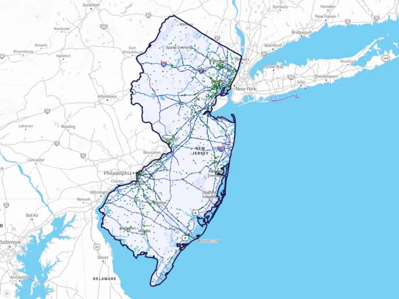
Between 2018 and 2020, 1,596 crashes resulted in fatalities along New Jersey roadways. MoneyGeek identified the state's deadliest stretches of road.

Out of New Jersey's 85,108 miles of road, we included 789 roads in our study. The analysis covered risky driving behaviors (drunk driving, speeding and distracted driving) and how crash frequency shifted by season.
Key Findings

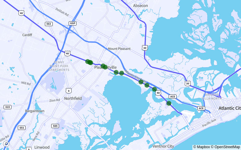
  • US-40 from West End Avenue to Noah's Road, which passes through Egg Harbor Township, Pleasantville and Atlantic City, is the deadliest stretch of road in New Jersey. Between 2018 and 2020, 11 fatal accidents occurred here.
  • Over 40% of all fatal accidents in New Jersey between 2018 and 2020 involved drunk driving or speeding. Of the two, drunk driving contributed to 359 deadly crashes. Speeding accounted for 327.
  • Distracted driving was involved in 19.6% of accidents. It contributed to 313 deadly crashes between 2018 and 2020. In a separate study, MoneyGeek ranked New Jersey ninth-worst in the U.S. for distracted driving.
  • October had the most fatal accidents between 2018 and 2020. A total of 10.4% (166) of all deadly crashes within these three years happened during this month. September and July followed, with 164 (10.3%) and 153 (9.6%) accidents, respectively.
  • Middlesex County had the highest number of deadly crashes of any county. The majority of these accidents happened on I-95.

10 Deadliest Road Stretches in New Jersey


  • 1. US-40 from West End Avenue to Noah's Road
    Cities:Egg Harbor Township | Pleasantville | Atlantic City
    US-40 from West End Avenue to Noah's RoadEgg Harbor Township | Pleasantville | Atlantic City

    • 11Fatal Accidents
    • 11fatalities
    • 3Crashes Per Mile
    • 3.9 milesdistance
    • (39.36740556, -74.47287222)start
    • (39.39353333, -74.53834444)end
    • [ 1 4 5 6 9 12 14 16 17 19 20]points
    • 31ordering
    • {'Egg Harbor Township', 'Pleasantville', 'Atlantic City'}localities
    • {'Atlantic'}counties
    • TRUEintersect
    • US-40TWAY_ID

  • 2. US-322 from Village Parkway to E. Garwood Avenue
    Cities:Gloucester County
    US-322 from Village Parkway to E. Garwood AvenueGloucester County

    • 10Fatal Accidents
    • 12fatalities
    • 2Crashes Per Mile
    • 4.6 milesdistance
    • (39.63775556, -74.9345)start
    • (39.68768333, -74.99108889)end
    • [ 1 9 11 12 13 16 17 19 21 22]points
    • 22ordering
    • {'Not Applicable'}localities
    • {'Gloucester'}counties
    • TRUEintersect
    • US-322TWAY_ID

  • 3. I-95 from Exit 74 to the Vince Lombardi Travel Plaza
    Cities:Ridgefield | Teaneck | Fort Lee | Englewood | Ridgefield Park | Leonia
    I-95 from Exit 74 to the Vince Lombardi Travel PlazaRidgefield | Teaneck | Fort Lee | Englewood | Ridgefield Park | Leonia

    • 10Fatal Accidents
    • 11fatalities
    • 2Crashes Per Mile
    • 4.2 milesdistance
    • (40.85269722, -73.95831667)start
    • (40.82608611, -74.03071389)end
    • [ 8 9 10 13 18 21 28 38 41 50]points
    • 24ordering
    • {'Ridgefield', 'Teaneck', 'Fort Lee', 'Englewood', 'Ridgefield Park', 'Leonia'}localities
    • {'Bergen'}counties
    • TRUEintersect
    • I-95TWAY_ID

  • 4. US-1 from Garden Street to US Highway 22
    Cities:Elizabeth | Newark
    US-1 from Garden Street to US Highway 22Elizabeth | Newark

    • 10Fatal Accidents
    • 10fatalities
    • 2Crashes Per Mile
    • 4.1 milesdistance
    • (40.65283611, -74.21339167)start
    • (40.70675, -74.18054722)end
    • [ 3 7 10 15 16 17 22 25 33 37]points
    • 24ordering
    • {'Elizabeth', 'Newark'}localities
    • {'Union', 'Essex'}counties
    • TRUEintersect
    • US-1TWAY_ID

  • 5. SR-21 from Miller Street to 4th Avenue
    Cities:Newark
    SR-21 from Miller Street to 4th AvenueNewark

    • 9Fatal Accidents
    • 10fatalities
    • 3Crashes Per Mile
    • 2.9 milesdistance
    • (40.71591944, -74.18404167)start
    • (40.75660278, -74.16683611)end
    • [0 1 2 4 5 6 7 8 9]points
    • 27ordering
    • {'Newark'}localities
    • {'Essex'}counties
    • TRUEintersect
    • SR-21TWAY_ID

  • 6. I-80 from Exit 55B to Exit 60
    Cities:Woodland Park | Elmwood Park | Paterson | West Paterson
    I-80 from Exit 55B to Exit 60Woodland Park | Elmwood Park | Paterson | West Paterson

    • 8Fatal Accidents
    • 9fatalities
    • 2Crashes Per Mile
    • 3.4 milesdistance
    • (40.89866389, -74.19823889)start
    • (40.90206667, -74.13257222)end
    • [ 3 4 15 17 23 25 26 29]points
    • 19ordering
    • {'Woodland Park', 'Elmwood Park', 'Paterson', 'West Paterson'}localities
    • {'Bergen', 'Passaic'}counties
    • TRUEintersect
    • I-80TWAY_ID

  • 7. SR-27 from Seminary Avenue to Grant Street
    Cities:Linden | Rahway | Roselle
    SR-27 from Seminary Avenue to Grant StreetLinden | Rahway | Roselle

    • 8Fatal Accidents
    • 8fatalities
    • 2Crashes Per Mile
    • 3.3 milesdistance
    • (40.61539167, -74.28552222)start
    • (40.649775, -74.2416)end
    • [ 0 2 3 6 7 8 13 20]points
    • 19ordering
    • {'Linden', 'Rahway', 'Roselle'}localities
    • {'Union'}counties
    • TRUEintersect
    • SR-27TWAY_ID

  • 8. I-95 from Exit 13 to Exit 14
    Cities:Newark | Elizabeth
    I-95 from Exit 13 to Exit 14Newark | Elizabeth

    • 7Fatal Accidents
    • 8fatalities
    • 1Crashes Per Mile
    • 4.9 milesdistance
    • (40.64854444, -74.20091944)start
    • (40.70809444, -74.150725)end
    • [ 2 3 7 14 43 47 49]points
    • 10ordering
    • {'Newark', 'Elizabeth'}localities
    • {'Union', 'Essex'}counties
    • TRUEintersect
    • I-95TWAY_ID

  • 9. US-9 from Spring Valley Road to Old Mill Road
    Cities:Old Bridge
    US-9 from Spring Valley Road to Old Mill RoadOld Bridge

    • 7Fatal Accidents
    • 8fatalities
    • 2Crashes Per Mile
    • 4.1 milesdistance
    • (40.37235833, -74.30659444)start
    • (40.43139444, -74.30261389)end
    • [ 1 14 16 19 26 27 33]points
    • 12ordering
    • {'Old Bridge'}localities
    • {'Middlesex'}counties
    • TRUEintersect
    • US-9TWAY_ID

  • 10. SR-27 from La Rose Avenue to S. Adelaide Avenue
    Cities:Franklin Park | Highland Park | North Brunswick | New Brunswick
    SR-27 from La Rose Avenue to S. Adelaide AvenueFranklin Park | Highland Park | North Brunswick | New Brunswick

    • 7Fatal Accidents
    • 7fatalities
    • 2Crashes Per Mile
    • 3.4 milesdistance
    • (40.47316944, -74.49067778)start
    • (40.49801389, -74.43429167)end
    • [ 1 10 11 12 17 18 21]points
    • 14ordering
    • {'Franklin Park', 'Highland Park', 'North Brunswick', 'New Brunswick'}localities
    • {'Somerset', 'Middlesex'}counties
    • TRUEintersect
    • SR-27TWAY_ID

Drunk Driving Involved in 22.5% of Fatal Accidents

Of the 1,596 deadly accidents in New Jersey between 2018 and 2020, 359 involved drunk driving. That's 22.5% of all reported incidents, more than those involving speeding, distracted driving and winter weather.

Even small amounts of alcohol affect driving ability in ways most drivers underestimate.

In New Jersey, the legal blood alcohol concentration (BAC) limit is 0.08%, about four drinks. Two drinks can push a driver's BAC to 0.02%. At that concentration, visual tracking already starts to suffer. The ability to focus on more than one thing at once drops, too.

A DUI conviction carries consequences that last for years. Drivers face license suspension and fines; some also serve jail time. The conviction also raises car insurance rates in New Jersey. Fewer carriers are willing to insure drivers with a DUI on record.

Speeding Is a Factor in 20.5% of Fatal Crashes

In 2020, 38,824 lives were lost in U.S. motor vehicle crashes, with speeding involved in 19% of those fatalities. In New Jersey, speeding was a factor in 327 (20.5%) of all deadly crashes in New Jersey from 2018 to 2020.

Speeds above the limit reduce vehicle control. At higher speeds, stopping distance increases and the margin for error shrinks.

Distracted Driving Contributed to 19.6% of Fatal Accidents

Distracted driving contributed to 313 deadly crashes in New Jersey from 2018 to 2020. That's 19.6% of all recorded incidents.

The state has a distracted driving law prohibiting drivers from talking or texting on their cellphones. New Jersey still ranks ninth-worst in the U.S. for distracted driving, according to a separate MoneyGeek study.

October Had More Fatal Accidents Than Any Other Month

October recorded the most fatal accidents from 2018 to 2020 at 166 (10.4%). September and July followed, with 164 (10.3%) and 153 (9.6%) fatal crashes.

Driving Safely Protects You, Others and Your Wallet

Keeping New Jersey's roadways safe is the responsibility of all drivers. Safe driving reduces crash risk and lowers what you pay for coverage. Sometimes you can't prevent a crash. In these situations, having full coverage car insurance provides a financial buffer. 

The average cost of car insurance in New Jersey is $1,674 a year. Where you live affects your premium. For example, auto insurance in Newark, the state's most populous city, costs $1,775 a year. Drivers pay around $1,573 a year in Jersey City.

Besides your ZIP code, insurers consider other factors when calculating your premium. These include your age, driving history and car's make and model. Comparing quotes from several providers is the most reliable way to find the cheapest car insurance.

Fatal Accidents and Most Dangerous Roads: County Breakdown

The number of deadly crashes varied across New Jersey's counties. The five counties with the highest numbers accounted for around 38% of all fatal accidents.

Middlesex County had the highest count of fatal accidents from 2018 to 2020, at 151. Most occurred on I-95, with speeding and drunk driving as the leading factors.

Methodology

MoneyGeek analyzed data from the National Highway Traffic Safety Administration Fatality Analysis Reporting System (FARS) database using fatality data from 2018, 2019 and 2020.

About Doug Milnes, CFA


Doug Milnes

Doug Milnes is a CFA charterholder with over 10 years of experience in corporate finance. He led the Credit Cards vertical at MoneyGeek. At Duff and Phelps, he performed valuations. He later conducted financial planning and analysis at several other companies. His analysis has been cited by U.S. News & World Report, The Hill, the Los Angeles Times, the New York Times and many other outlets.

Doug holds a master's degree in data science from Northwestern University. He writes about credit card strategy, including debt management and rewards.


Sources