
MoneyGeek analyzed 2,820 fatal crashes on Michigan's roadways between 2018 and 2020 to find the deadliest stretches of road in the state. Michigan has 256,579 miles of road; the study covered 1,742 of them. The study examined drunk driving, speeding, distracted driving, winter weather and time of year as crash factors.
Michigan Fatal Accident Study
Michigan’s Deadliest Roads and Fatal Accident Statistics
Updated: July 31, 2026
Advertising & Editorial Disclosure

Key Findings
- SR-3 Gratiot Avenue from Liberal Street to Van Dyke Avenue is Michigan's deadliest road. Sixteen fatal accidents happened between 2018 and 2020.
- Drunk driving contributed to 28.5% of fatal accidents (803 of the 2,820 statewide).
- Winter weather contributed to 4.8% of Michigan's deadly crashes, even though MoneyGeek ranked Michigan as the deadliest state for winter driving.
- Speeding contributed to 25.9% of fatal accidents (729 total) from 2018 to 2020. Distracted driving accounted for 6.3% (179) in those three years.
- August had the most fatal accidents (331) between 2018 and 2020. July had 301; September had 289.
- Wayne County recorded the most deadly crashes (539). I-94 was the deadliest road in the county, with 24 fatal accidents.
10 Deadliest Road Stretches in Michigan
- 1. SR-3 Gratiot Avenue from Liberal Street to Van Dyke AvenueCities:Detroit
 Detroit
- 16Fatal Accidents
- 18fatalities
- 3Crashes Per Mile
- 4.7 milesdistance
- (42.43961389, -82.97469444)start
- (42.37878333, -83.01466667)end
- [ 0 5 6 7 9 10 11 13 16 17 18 19 21 22 23 24]points
- 55ordering
- {'Detroit'}localities
- {'Wayne'}counties
- TRUEintersect
- SR-3 Gratiot AveTWAY_ID
- 2. I-94 from Exit 198A to Exit 202Cities:Romulus | Taylor
 Romulus | Taylor
- 12Fatal Accidents
- 12fatalities
- 3Crashes Per Mile
- 4.2 milesdistance
- (42.23806944, -83.34654167)start
- (42.26463333, -83.27241944)end
- [ 8 9 17 18 23 35 40 52 56 63 66 69]points
- 34ordering
- {'Romulus', 'Taylor'}localities
- {'Wayne'}counties
- TRUEintersect
- I-94TWAY_ID
- 3. I-96 from Exit 182 to Exit 188Cities:Detroit
 Detroit
- 10Fatal Accidents
- 11fatalities
- 2Crashes Per Mile
- 5.0 milesdistance
- (42.37840556, -83.23266389)start
- (42.36655, -83.13705278)end
- [12 18 21 26 27 29 32 33 35 37]points
- 20ordering
- {'Detroit'}localities
- {'Wayne'}counties
- TRUEintersect
- I-96TWAY_ID
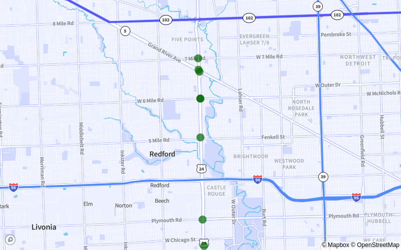
- 4. US-24 Telegraph Road from 7 Mile Road to Cathedral AvenueCities:Redford Township | Detroit
 Redford Township | Detroit
- 8Fatal Accidents
- 9fatalities
- 2Crashes Per Mile
- 4.6 milesdistance
- (42.42895556, -83.27796944)start
- (42.36170278, -83.27513056)end
- [ 3 6 8 15 16 18 19 20]points
- 14ordering
- {'Redford Township', 'Detroit'}localities
- {'Wayne'}counties
- TRUEintersect
- US-24 Telegraph RdTWAY_ID
- 5. I-94 from Exit 222A to Exit 227Cities:Harper Woods | Detroit | Saint Clair Shores
 Harper Woods | Detroit | Saint Clair Shores
- 7Fatal Accidents
- 9fatalities
- 1Crashes Per Mile
- 5.0 milesdistance
- (42.40249444, -82.96885278)start
- (42.46510833, -82.92128333)end
- [20 22 48 58 65 68 73]points
- 10ordering
- {'Harper Woods', 'Detroit', 'Saint Clair Shores'}localities
- {'Wayne', 'Macomb'}counties
- TRUEintersect
- I-94TWAY_ID
- 6. SR-59 Highland Road from N Oakland Boulevard to Cass Lake RoadCities:Waterford
 Waterford
- 7Fatal Accidents
- 8fatalities
- 2Crashes Per Mile
- 4.1 milesdistance
- (42.66021667, -83.43011389)start
- (42.64126111, -83.35479722)end
- [ 0 3 6 8 9 10 12]points
- 12ordering
- {'Waterford', 'Not Applicable'}localities
- {'Oakland'}counties
- TRUEintersect
- SR-59 Highland RdTWAY_ID
- 7. I-696 from Exit 21 to Exit 16Cities:Warren | Pleasant Ridge | Madison Heights | Royal Oak
 Warren | Pleasant Ridge | Madison Heights | Royal Oak
- 7Fatal Accidents
- 8fatalities
- 2Crashes Per Mile
- 3.7 milesdistance
- (42.49096667, -83.07236111)start
- (42.47520278, -83.14136389)end
- [ 2 3 5 6 8 9 11]points
- 13ordering
- {'Warren', 'Pleasant Ridge', 'Madison Heights', 'Royal Oak'}localities
- {'Oakland', 'Macomb'}counties
- TRUEintersect
- I-696TWAY_ID
- 8. SR-120 Holton Road from Hallstrom Castle Drive to East River RoadCities:Muskegon County
 Muskegon County
- 7Fatal Accidents
- 7fatalities
- 2Crashes Per Mile
- 4.8 milesdistance
- (43.35704167, -86.16746944)start
- (43.29368333, -86.20605)end
- [0 1 2 5 6 7 8]points
- 10ordering
- {'Not Applicable'}localities
- {'Muskegon'}counties
- TRUEintersect
- SR-120 Holton RdTWAY_ID
- 9. US-131 from Exit 84A to Exit 82BCities:Grand Rapids
 Grand Rapids
- 6Fatal Accidents
- 8fatalities
- 3Crashes Per Mile
- 1.9 milesdistance
- (42.95538889, -85.67138889)start
- (42.92873056, -85.6817)end
- [ 0 18 21 24 29 30]points
- 19ordering
- {'Grand Rapids'}localities
- {'Kent'}counties
- TRUEintersect
- US-131TWAY_ID
- 10. Greenfield Road from Joy Road to Curtis StreetCities:Detroit
 Detroit
- 6Fatal Accidents
- 8fatalities
- 1Crashes Per Mile
- 4.5 milesdistance
- (42.35813889, -83.19688889)start
- (42.42321944, -83.19958056)end
- [0 1 2 4 6 7]points
- 8ordering
- {'Detroit'}localities
- {'Wayne'}counties
- TRUEintersect
- Greenfield RdTWAY_ID
Drunk Driving Involved in 28.5% of Fatal Accidents
Drunk driving was Michigan's leading cause of fatal crashes from 2018 to 2020. It accounted for 803 of 2,820 statewide accidents.
Alcohol impairs driving before a driver hits Michigan's legal limit. A blood alcohol concentration (BAC) of 0.08% marks legal intoxication in Michigan, but even a BAC of 0.02% impairs vision and makes it harder to perform two tasks at once.
A DUI conviction in Michigan can mean license suspension, restricted driving privileges and jail time. It also triggers an SR-22 filing requirement, and auto insurance rates climb above standard levels.
Speeding Caused 25.9% of Fatal Crashes
Speeding caused 729 fatal accidents in Michigan from 2018 to 2020. It was the second-leading cause of deadly crashes.
Higher speeds extend stopping distances. On both surface roads and highways, that leaves less room to avoid a collision.
Distracted Driving Contributed to 6.3% of Fatal Accidents
Distracted driving was the third-leading cause of fatal accidents in Michigan from 2018 to 2020. It caused 179 deadly crashes (6.3% of all fatal crashes). Michigan was safer than 66% of states for distracted driving, per a separate MoneyGeek analysis.
August Had More Fatal Accidents Than Any Other Month
August led all months in fatal accidents from 2018 to 2020, with 331 crashes (11.7% of the statewide total). July followed with 301 (10.7%), then September with 289 (10.2%). The numbers cut against Michigan's standing as the most dangerous state for winter driving, per a separate MoneyGeek study.
Auto Insurance Costs in Michigan
Full coverage averages $4,333 a year in Michigan, but rates vary sharply by city. Detroit averages $5,471; Grand Rapids averages $1,738, a difference of $3,733 a year.
Individual rates reflect driving record, ZIP code and coverage level. MoneyGeek's analysis of the cheapest car insurance companies breaks down rates by insurer nationally.
Fatal Accidents and Most Dangerous Roads: County Breakdown
Michigan's five deadliest counties combined for 1,156 crashes (41% of all fatal accidents from 2018 to 2020).
Wayne County led with 539 crashes (19% statewide). I-94 was the deadliest road, with 24 fatal accidents. Speeding caused the most county fatalities (172); drunk driving caused 142.
Methodology
MoneyGeek used the National Highway Traffic Safety Administration Fatality Analysis Reporting System (FARS) database. Fatality data covers 2018, 2019 and 2020; the 2020 figures were the most recent available at the time of publication.
About Doug Milnes, CFA

Doug Milnes is a CFA charterholder with over 10 years of experience in corporate finance. He led the Credit Cards vertical at MoneyGeek. At Duff and Phelps, he performed valuations. He later conducted financial planning and analysis at several other companies. His analysis has been cited by U.S. News & World Report, The Hill, the Los Angeles Times, the New York Times and many other outlets.
Doug holds a master's degree in data science from Northwestern University. He writes about credit card strategy, including debt management and rewards.
Sources
- Federal Highway Administration. "Highway Statistics Series." Accessed July 31, 2026.
- Michigan State Police. "Impaired Driving Law." Accessed July 31, 2026.
- National Highway Traffic Safety Administration. "Drunk Driving." Accessed July 31, 2026.
- National Highway Traffic Safety Administration. "Fatality Analysis Reporting System (FARS)." Accessed July 31, 2026.